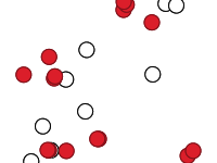
Distribuzione delle segnalazioni e dei ritrovamenti di Cystoseira ricavate dalla figura n. 1 presente nella pubblicazione Daniele Grech et al. 2019 in INPUT aCAdemy 2019. Marine forests (Fucales, ochrophyta) in a low impacted mediterranean coastal area: current knowledge and future perspectives a phycological review in Sinis Peninsula and the gulf of Oristano (Sardinia island, Italy).
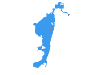
The Digital elevation model of San Teodoro lagoon, East Sardinia, Italy, the bathymetry as been acquired in the 20 April 21, the water level is refered to the maximal tide reached in the day. The Acquisition has been performed with a single beam chirp echosounder, the GPS positioning and tidal variation as been rectified by an GPS RTK correction. The Coast line has been positioned by satellite world imagery, verified and rectified by GPS RTK correction. During acquisition the navigation interlines were minimum, 10 m maximum 20 m inside the lagoon, in the mouth channel and the harbour, the navigation interlines were minimum 5 m maximum 10 m. The projection is UTM, zone 32N, the datum is WGS 84. The Grid interpolation has been performed in a variable resolution from 10X10 metres p to 5X5 metres. The Acquisition and the data processing have been performed By IAS CNR of Oristano by Alessandro Conforti.